2 posts tagged with "T-Route"

View All Tags

Continental-Scale Streamflow Simulation Using Kriging in the NGIAB-NRDS NextGen Ecosystem


· 5 min read
Suma Battula
Department of Geological SciencesThe University of Alabama
Kunal Sarna
Department of Computer ScienceThe University of Alabama
Sonali Vyas
Department of Computer ScienceThe University of Alabama
Harsha Vemula
DevOps EngineerAlabama Water Institute
Arpita Patel
Assistant Director, IT and DevOpsAlabama Water Institute
Jonathan Frame
Assistant Professor, Department of Geological SciencesAlabama Water Institute, The University of Alabama

Hourly streamflow kriging is now operational within the NextGen Research Data Stream, delivering spatially complete estimates for all NextGen v2.2 hydrofabric catchments. This observation-based approach supports streamflow analysis, NWM calibration, forecasting, and data assimilation for ungauged basins.

Kriging-Based Streamflow Estimation

Process-based hydrologic models are subject to structural and forcing uncertainties throughout the modeling domain, yet these can only be evaluated where USGS gauge observations exist. There is a clear need for a data-driven, observation-based framework that provides spatially complete streamflow estimates with well-characterized uncertainty, independent of model structure. Recent results from the CIROH project "Developing and Benchmarking Data Assimilation Methods on a Standardized Testbed" suggest that a simple Kriging interpolation between USGS gauged locations is both scalable and accurate for producing such spatially complete streamflow fields. As a pure data-driven method, this interpolation cannot be used directly for forecasting, but it serves as a valuable "pseudo-observation" for streamflow analysis and historical reconstruction.
Cross-Institutional Collaboration Enhances Hydrologic Modeling in the Logan River Watershed

· 3 min read
Bhavya Duvuri
Machine Learning ResearcherAlabama Water Institute
Ayman Nassar
Postdoctoral ResearcherUtah State University
James Halgren
Assistant Director of ScienceAlabama Water Institute
Arpita Patel
DevOps Manager and Enterprise ArchitectAlabama Water Institute
Josh Cunningham
Software EngineerAlabama Water Institute
David Tarboton
ProfessorUtah Water Research Laboratory
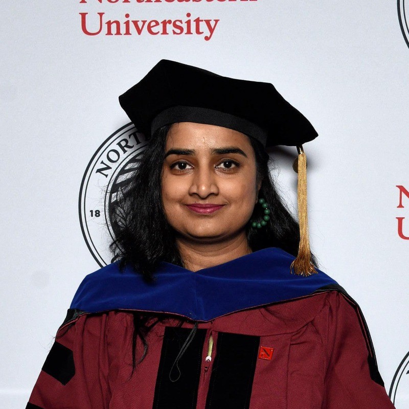
A before-and-after comparison of the corrected catchment for the Logan River. Text: 'Correcting hydrofabric by removing catchments that do not drain into gauge'
Figure 1. A corrected reach arising from the UA-USU collaboration.

Recent collaboration between researchers in the Cooperative Institute for Research to Operations in Hydrology (CIROH) from University of Alabama (UA) and Utah State University (USU) highlighted the value of cross-institutional partnerships in improving community hydrologic modeling. Focused on the Logan River watershed, this joint effort demonstrated how sharing tools, knowledge, and infrastructure can accelerate both model development and scientific discovery.

Through this engagement, USU researchers gained deeper understanding of the NextGen framework and T-Route modeling library, empowering them to improve physical process representations for the Logan River watershed for heightened simulation fidelity. The collaboration also provided valuable exposure to the developmental side of complex modeling tools, offering insights into framework design, automation workflows, and best practices for model setup and calibration. Both teams benefited from exposure to alternative research tools and methods, which helped enhance and refine the community development pipeline.